| &nsbp; | |||||||||||||||||||
|
|
|||||||||||||||||||
 |
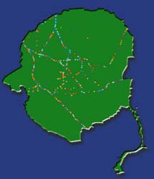
Research Magazine > ARCHIVE > Winter 00 > Article Behind the Scenes A good map can show you where to go. But a Geographic Information System (GIS) map reveals a good deal more. Advanced GIS maps combine data from satellites, remote sensors and other sources to display a wide variety of information in ways that help researchers best put it to use. For example, UGA geography graduate student Rakesh Malhotra uses GIS maps that may help wildlife management officials reduce the number of car accidents involving deer near UGA’s Savannah River Ecology Lab in Aiken, S.C. The images not only show where such accidents have occurred in the past 10 years, but also the spatial relationships of the collisions and surrounding deer habitat. Because these maps also show landscape features — such as roads, streams and buildings — they trim research time in half by eliminating the trips researchers would otherwise make to collect that information on foot, said Deno Karapatakis, a technician at SREL’s Remote Sensing/GIS Laboratory. Other mapping techniques available at that shop include Global Positioning System (GPS) and Remote Sensing. GPS captures positional information from 25 satellites that orbit the Earth providing accurate latitude and longitude measurements. Remote Sensing enables researchers to obtain information from aerial photography and satellite data. SREL’s GIS shop, one of several at the university, primarily works with faculty on site, mainly because of its shared address. However, the shop supports other UGA researchers, like Malhotra. For more information about SREL’s GIS lab, call (803) 725-8228.
Return to the Winter 2000 Index
|
|
|