| &nsbp; | |||||||||||||||||||
|
|
|||||||||||||||||||
 |
Research Magazine > ARCHIVE > Spring 00 > Article HOT-LANTA
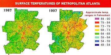
Tempers aren't the only thing heating up during Atlanta's grueling rush hours. The mercury is rising too. Miles of heat-absorbing asphalt, concrete and sprawling development are responsible for raising temperatures an astonishing 5 to 10 degrees higher in metro Atlanta than surrounding areas, according to UGA geogra-pher C.P. Lo. As a result, Atlanta now carries a truly modern moniker: "urban heat island." Scientists have documented the phenomenon in major cities around the globe where acres of vegetation and forests are replaced by miles of man-made materials. But less understood is the effect that these increased temperatures have on the local environment. To explore this uncertainty, in 1996 NASA funded an interdisciplinary research team from across the country, including Lo, to study how urban heat islands develop over time, as well as what impact these islands and their continued expansion may have on weather and air quality. Drawing on the diverse skills of meteorologists, foresters, geographers and others, NASA's Project ATLANTA - a tortured acronym for ATlanta Land use ANalysis: Temperature and Air quality - reveals surprising information about the modern city that might influence not only how Atlanta charts future growth, but also how other cities are developed in the future. One of the most unexpected results of the project, Lo said, is the finding that the 13-county Atlanta metropolitan area is losing an average of 56 acres of trees per day. "I did not even think about it being so large because there still is so much forest to see in Atlanta," said Lo, who used Project ATLANTA funding to map the growth of the urban heat island effect. "But in reality it is 56 acres a day, which is pretty astonishing." In a sense, Atlanta is a victim of its own success. As more new residents are drawn by the region's booming economy and quality of life, trees succumb to the new development and the urban heat island effect emerges. This is a serious threat to air quality, Lo said, driving up temperatures and contributing to increased ground-level ozone - a toxic component of the brown smog that blankets many industrialized cities. Ozone forms in Atlanta primarily on hot summer days when heat stimulates chemical reactions in the emissions of more than 2 million vehicles driven through the region every day. Other large sources of ozone, such as power plants and even lawn mowers, also contribute to the problem. High ozone levels put Atlanta far below federal air quality standards, which could cost the city more than $1 billion in lost federal highway and transit funds in the next six years. With 65 ozone alert days during this past summer warning Atlantans to limit outdoor activity, the city also contributes to the $50 billion in ozone-associated health care costs that the American Lung Association estimates Americans spend each year. Because heat contributes to the production of ozone, the urban heat island effect clearly exacerbates the problem, Lo said. However, because Atlanta remains so green with trees, it may be difficult for residents to grasp or believe the true depth of the tree loss that contributes to this effect.
Mapping out the problem Lo's maps make the problem clear. Using satellite images (specifically, Landsat Multispectral Scanner images) dating from 1973, he developed what is termed a "land use/cover map," reflecting in exceptional detail how the city's landscape has changed during the past quarter century. Lo's data reveals an incredible 47 percent increase in residential development in the metro area just in the past 10 years and a 16 percent increase in high-density (commercial) developments in the same period, stretching out from the city center along the major highways, devouring the region's forest and vegetation. Lo charts urban sprawl, grouping land use into six major categories: high-density urban use, low-density urban use, cultivated/exposed land, cropland/grassland, forests and water. Plotting these categories on a map and then showing how they have changed over the years is painstaking work. With satellite images, taken in three- to five-year increments, dating back more than 20 years, Lo's most pressing research problem is accuracy. Because each satellite image in the study was taken in a different month, time of day and, as the years progressed, from different satellites, Lo faces a complex challenge of matching images from one year to the next. "I can't put the 1993 satellite image on top of 1979 and hope they would exactly match up because the satellite images always have distortions," Lo said. "We have to deal with these so that each year's data will match up completely. If they don't match up, we have a lot of error. Also, if you take a picture on a day when the light is not very strong versus a day when the sun is very strong, you have different illuminations. This is big trouble to us. To solve this problem, we pick one particular good scene and then try to standardize everything else." To match up satellite images from different years, Lo uses a variety of tools, including the Universal Transverse Mercator coordinate system, or UTM, which divides the earth into zones that are measured in meters, making plotting locations easier than it would be using the traditional degrees, minutes and seconds of latitude and longitude. Using a process known as geometric rectification, Lo can register each satellite image to the same set of coordinates based on the UTM. Once the images are matched, he has to address the equally, if not more, complex issue of determining the land-use categories. False color composites created by combining green, red and infrared bands of the satellite images help with this process, dividing the satellite images into a palette of colors that differentiate between, say, a lake and a parking lot. However, even with the color variations, many classifications are difficult to determine at first glance. "For example, crop land and grass land are very easy to mix up," Lo said. "Golf courses also are hard to separate from crop land and grass land." A computer program helps with this process by grouping even the most subtle color changes into what Lo calls "clusters." Once the clusters are organized, he looks at an example of each cluster to define which category it belongs to - residential, water, forest, etc. Once Lo defines a color cluster as water, for example, like an elaborate paint-by-number painting, the computer begins labeling all similar clusters with the same definition. "Some clusters are not always distinctive or separate because they are mixed [color values]. Those that are pure we finish first," he said. "Then you go back to the clusters that are a problem and filter all the noises. For example, we have a bit of a problem with low-density residential because they often have forest mixed in the suburban areas." In areas where the satellite images fail to produce reasonable assurance of classifications, Lo relies on aerial photographs from a variety of sources. These photographs are much clearer than a distant satellite image, but are best reserved for the more complex classifications, he said, because mapping directly from hundreds of photographs is more time- consuming than examining a single satellite image. In addition, Lo sometimes will drive to Atlanta to verify a particularly complicated classification. "We have to be very careful about it because our data is recognized as very reliable," Lo said. The end result is that Lo's maps are the lynchpin of Project ATLANTA in terms of classifying land use in the city, said Dale Quattrochi, NASA Marshall Space Flight Center geographer and study organizer. "Dr. Lo's work is the absolute foundation for the entire project," Quattrochi said. "His work provides the critical element in understanding what has changed and what it has changed to." Building and expanding on Lo's work, other researchers in the project are studying how the land-use patterns identified on Lo's maps may affect weather, vegetation and air quality. Utah State University biometeorologist Robert Gillies produced a map from weather satellite data showing the expanse of the heat island effect. Where Lo's maps show the causes of the heat island, Gillies' map shows the temperature variations for different land uses. In looking at these variations, Gillies pays particular attention to the link between plants and the atmosphere - how the amount of soil and vegetation drive the surface temperature. As you urbanize, you replace the surface with artificial materials, shifting the energy balance of the surface," Gillies said. "We have found that there is a fairly strong relationship between the temperature of the surface and moisture in the soil as well as the extent of vegetation cover." Acting as Mother Nature's air conditioner, plants and soil release water into the atmosphere as they heat up. Evaporation and vegetation transpiration help combat the heat generated on a hot summer day. However, Gillies' work clearly shows that in the absence of vegetation that generates this natural coolant, temperatures rise. Manipulating the weather With the mercury rising, San Jose State meteorologists Robert Bornstein and Qing Lu Lin have found that the urban heat island effect causes Atlanta actually to influence its own weather patterns. Using data from the U.S. Weather Service Meteorological Station set up for the 1996 Olympics, Bornstein and Lin linked the formation of six thunderstorms during a nine-day period directly to the increased summer temperatures radiating from man-made surfaces across the city. While it may seem like science fiction for a city to generate its own weather, the process is fairly simple. As intense summer sunlight heats up the city, individual surfaces such as rooftops and asphalt absorb and store the sun's solar energy. After the sun sets for the day, those surfaces, much like red-hot coals in a grill, begin to release the stored heat energy back into the lower atmosphere, creating a bubble of warm air over the city. As cooler air from outside the city bumps into this warmer air, it sinks in the city's self-created low-pressure system. When the cooler air begins to heat up, it rises, forming clouds and precipitation. A key indicator that a storm is generated by the urban heat island effect rather than Mother Nature is noting the time of day the storm occurs, Bornstein said. Since most summer thunderstorms and rainfall occur in the afternoons in Georgia, it is unusual, he said, to find six storms in nine days occurring just at dawn or as early as 2 a.m. "We have seen this before in other cities," Bornstein
said. "On the one hand, increased precipitation can have
negative consequences in terms of increased risk for flooding
and highway disruptions, but the cooler, convergence air flowing
into the city's warm areas does take some of the pollution out
of the lower levels of the atmosphere to the higher levels." For example, air quality modeler Haider Taha, stationed at Berkley's National Laboratory, has found that if Atlanta lowers the surface temperature by 2 to 4 degrees Fahrenheit, the city could bring down ozone levels by 10 to 14 percent, Quattrochi said. "This is significant," he said. Project ATLANTA could not have come at a more opportune time. Led by an initiative from Georgia Gov. Roy Barnes, the metro area currently is undergoing a major self-analysis of its largely unchecked urban sprawl. Data generated by Project ATLANTA then is not confined to a scientific journal, Lo said; rather a primary goal of the project is to pass along study insights as quickly as they are generated. With community workgroups meeting quarterly in Atlanta to bring together representatives from industry, state agencies, nonprofit groups and interested citizens, researchers have been able to pass along relevant and timely data to the region's decision-makers, as well as to provide recommendations on how to address some of the problems indicated by the study. Among the major recommendations is to drive down the urban heat island effect by changing the reflectivity of man-made surfaces to those that reflect the sun's heat, rather than absorb it. For example, the researchers strongly urge developers to use white rooftops rather than black. In fact, NASA's Quattrochi said, Georgia is on the forefront of this change by offering an incentive program to builders if they use re-roofing material that is at least 60 percent reflective. Quattrochi and his colleagues also would like to see asphalt changed from black to white, possibly by imbedding white paint crystals in new roadways to change the surface reflectivity. In addition, the researchers recommend replenishing the metro area's forests and lost vegetation, and minimizing the number of forested acres eliminated when land is developed. With phase one of Project ATLANTA complete, Lo, Quattrochi and their fellow team members hope to continue their work together with a study that delves even deeper into Atlanta's land-use issues. The team also plans to study similar issues in Houston, Texas, which has received national attention for its own urban sprawl and ozone problems. Interesting to researchers, and eventually the communities studied, will be maps that can combine the physical attributes of the heat urban island effect with socio-economic patterns, Lo said. "Changes in land use are the result of economic development," he said. "Income and greenness relate to each other - with very interesting implications. As you become wealthier, unless you live in an apartment, you are more likely to have a big home, with a big yard, with more trees. If we can better understand the patterns of how people use their money, we can model future air quality in a much better way." Enthusiasm for continuing Project ATLANTA extends to the governor's office. In a recent letter of support to NASA administrator Dan Goldin, Gov. Barnes wrote, "Continued research and data gathering will be critical in quantifying and measuring the economic and environmental impact of various strategies and will enable Georgia to continue effective implementation of techniques for pollution prevention and control." Georgia's advances eventually may become a case study for other
cities. "How can we make cities more sustainable, living environments? Atlanta is contributing to those answers."
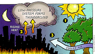 1. During the day, the sun bakes the city's concrete, asphalt and rooftops. 2. After sundown, these hot surfaces release their stored heat. 3. Cooler air moves in from outlying areas, collides with the city's heat and generates a predawn thunderstorm. E-mail chpanglo@arches.uga.edu for more information. Jennifer T. Daly is an award-winning freelance writer living in Atlanta, Ga. A former staff writer for the Research Reporter, she has a bachelor's degree from the UGA College of Journalism and Mass Communication.
|
|
|