

A Sobering View From Above
by Anisa S. Jimenez
Startling growth rates in the 16-county Metro Atlanta area mean a loss of 54 acres of tree canopy and a gain of more than 28 acres of impervious, or constructed, surface—daily. Further research indicates the rate of increase in impervious surface is accelerating. How this compares to other cities in the Southeast isn’t known, but that is about to change. Elizabeth Kramer, public service assistant in UGA’s Institute for Ecology and director of the Natural Resources Spatial Analysis Laboratory, will create datasets showing changes in land covered by trees and other vegetation across urban areas of the Southeast. “Trees help protect air and water quality and maintain biodiversity,” said Kramer, whose research is being funded in part by the U.S. Department of Agriculture (USDA). “When we lose tree canopy, we lose the natural capabilities for moderating temperatures, resulting in higher cooling and heating costs.”
Trees also add to the “curb appeal” and desirability of homes. Research shows that in Athens, for example, a large tree planted in front of a house adds about 1 percent to the sales price. In addition, cutting trees to build subdivisions doesn’t automatically increase the economic value of the area.
“Yes, if you put houses on a piece of land instead of trees, you will get new revenues,” said Jeffrey Dorfman, co-director of the Land Use Studies Initiative at UGA. “But you will also have new expenditures. You will need roads, schools, libraries, trash collection, water and sewer services. It turns out, these amenities usually cost more than they bring in.”
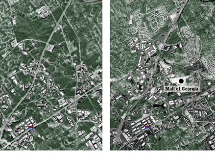
The images above, taken in 1991 (left) and again in 2001 (right) show growth in Gwinett County, including the addition of the Mall of Georgia.
To help community leaders and decision makers understand the ramifications of tree canopy loss, Kramer will create a time series for tree canopy and impervious cover such as land cover in roads, buildings, parking lots and turf grass. Time series refers to data collected and analyzed in an effort to understand underlying forces that can predict what will happen at equally spaced time intervals.
“The small-scale sample conducted in the Metro Atlanta area proved to be timely and cost- effective,” said Kramer. “Creating a dataset for the Southeast will provide a prototype that can be extended to the entire continental U.S., which would help evaluate the success of greenspace plans, for example.”
The datasets will be available on the Internet in a user-friendly format, even for those with no Geographic Information System (GIS) or remote sensing experience, making the data available to a much broader audience. New research shows that from 2001 to 2005, increases in impervious surface (pavement) nearly doubled to 55 acres daily, while the rate of tree canopy loss remained at 54 acres. Statewide, the rate of impervious surface development rose from 60 to 108 acres per day. The rate of tree canopy change during this same period shows a loss of 280 acres daily; however, this can be due in part to silviculture, the cultivation for forest trees. Data for Georgia have been completed, and other areas of the Southeast are soon to follow.
“In the short term, we hope to be able to compare development patterns of urban areas across the southeastern U.S. with one another,” said Kramer. “Also, we will create materials that will help educate urban foresters, local government staff, non-governmental organizations and others to use this information for tree ordinance development, watershed planning and other important applications.”
Staff and students at the Institute of Ecology’s Natural Resources Spatial Analysis Laboratory (NARSAL) will cooperate with the Southeast Extension Forester to create the datasets and develop outreach materials. The study will include cities such as Birmingham, Ala., Jacksonville, Fla., Raleigh, N.C. and Washington, D.C.
“This project will help people understand the impacts of tree canopy loss in their communities,” said Kramer. “Often it takes a bird’s eye view of change for them to understand how each individual land use decision has an impact.”
For more information contact Liz Kramer at lkramer@uga.edu.
For comments or for information please e-mail: rcomm@uga.edu
To contact the webmaster please email: ovprweb@uga.edu
![]()